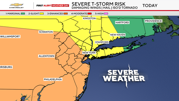
Tri-State Storm Timeline: Rain Ramps Up by Afternoon
Unsettled weather is making a loud return to the Tri-State region. The day starts off humid and wet, primarily for inland communities, with morning temperatures lingering in the mid-60s to low 70s.
As the afternoon progresses, atmospheric conditions will deteriorate rapidly across the metro area:
- Afternoon: Isolated to scattered downpours begin developing across inland and coastal zones.
- Evening: Severe thunderstorms peak, bringing torrential rain, damaging wind gusts, large hail, and a high likelihood of flash flooding.
- Overnight: Heavy rainfall begins to taper off in the early morning hours on Wednesday as the front pushes offshore.
Flood Watch Details and Expected Rainfall Totals
The National Weather Service flood watch remains active through 2 a.m. Wednesday for New York City and the majority of New Jersey.
Meteorologists warn that atmospheric moisture will allow storms to produce extreme rainfall rates of 1 to 3 inches per hour. Total rainfall accumulation could easily reach 2 to 3 inches or more before the system moves out, presenting severe risks for low-lying roads, basement units, and poor-drainage areas.
NYC Activates Flash Flood Emergency Plan
In response to the severe weather threat, the New York City Emergency Management Department issued an official weather alert and activated the city’s Flash Flood Emergency Plan.
City agencies are executing proactive measures to prepare municipal infrastructure for heavy runoff:
- Pre-storm targeted inspections in known flood-prone neighborhoods.
- Systematic clearing of catch basins and storm drains across all five boroughs to prevent street pooling.
Extended Outlook: Lower Humidity and Cooler Weather Ahead
There is good news behind the storm front. Once the wet weather exits early Wednesday morning, the Tri-State area can look forward to an extended stretch of pleasant summer weather.
The remainder of the week and the upcoming weekend feature:
- Consistently dry conditions and sunshine.
- Noticeably lower, comfortable humidity levels.
- High temperatures remaining in the lower 80s, which is refreshingly below average for late July.
Clouds will gradually increase at night, but we stay dry. Lows will be in the 60s in the suburbs to around 70 in the city.
NYC flood watch severe storms. Tri-State severe weather alert, NYC Flash Flood Emergency Plan, First Alert Weather Day, New Jersey flood watch.